 |
|
|
|
|
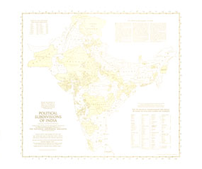
Political Subdivisions Of India Map 1946
Issue: April 1946
|
|
|
|
|
|
|
| Product Highlights |
| Political Subdivisions Of India Map 1946 |
| Item#: X NGC 041946b |
Because the hundreds of political subdivisions of India are so complex, this outline map was prepared to amplify the map of India and Burma which appeared in the same issue. Published in April 1946 with three articles on India, these historical maps capture the region known then as India a year before the independent countries of India and Pakistan were formed. The 1946 Political Subdivisions of India map features:
• Indian states are shaded, and British India, French, and Portuguese holdings are unshaded
• A key for political subdivisions too small to name
• Information on the political geography of India
• Cities with populations of more than 200,000
Coverage Area: India
|
|
 |
More Product Details
This map requires 7 business days to print and laminate prior to shipping.
Appearing in the April 1946 issue of the National Geographic Magazine, this Political Subdivisions Of India map has been reproduced from its original cartography in order to bring to life a beautiful poster previously only seen in National Geographic Magazine. This reproduction holds true to the high standards that National Geographic Maps are known for.
Perfect for home, office or classroom, this map also makes a great gift. Map collectors will surely want to add this map to their library.
The Paper version is printed on high quaility semi-gloss paper, perfect for framing.
The Laminated version uses 3mm laminate on both sides for durability, is easy to clean and markable.
From the National Geographic Classic Maps collection, this reproduction is just one of hundreds of titles available here. These maps are Printed on Demand. Sizes are approximate and may vary due to the nature of the trimming and laminating processes.
|
|
Shipping Conditions
Maps.com ships to Dometic US only
 | This product can only be shipped to the Domestic U.S.A. (No APO's or PO Boxes) |  | This map requires 2 business days to print and laminate prior to shipping. |
|
|
|
|


 Click here to zoom!