|
|
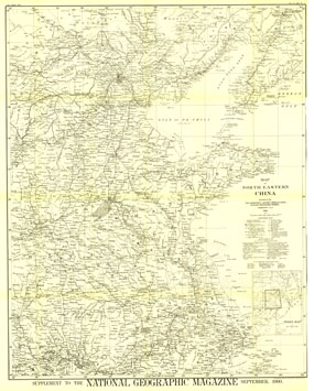
Map Of North Eastern China Map 1900
Issue: September 1900

|
|
|
|
|
|
|
| Product Highlights |
| Map Of North Eastern China Map 1900 |
| Item#: X NGC 091900 |
The first map of China printed by National Geographic, this historic black and white map is a true collectors item. Published in September 1900, it features translations of common terms and items of note such as the Great Wall and imperial tomb sites. The 1900 Map of North Eastern China features:
• Translations of geographical and other common terms
• Boundaries of provinces and Mongol clans or banners
• Railroads, roads, and mountains passes
• Imperial tombs and the Great Wall
• Markings to show where rivers become navigable for larger or smaller boats
• Inset of an index map
Coverage Area: North Eastern China
|
|
More Product Details
This map requires 7 business days to print and laminate prior to shipping.
Appearing in the September 1900 issue of the National Geographic Magazine, this Map Of North Eastern China map has been reproduced from its original cartography in order to bring to life a beautiful poster previously only seen in National Geographic Magazine. This reproduction holds true to the high standards that National Geographic Maps are known for.
Perfect for home, office or classroom, this map also makes a great gift. Map collectors will surely want to add this map to their library.
The Paper version is printed on high quaility semi-gloss paper, perfect for framing.
The Laminated version uses 3mm laminate on both sides for durability, is easy to clean and markable.
From the National Geographic Classic Maps collection, this reproduction is just one of hundreds of titles available here. These maps are Printed on Demand. Sizes are approximate and may vary due to the nature of the trimming and laminating processes.
|
|
Shipping Conditions
Maps.com ships to Dometic US only
 | This product can only be shipped to the Domestic U.S.A. (No APO's or PO Boxes) |  | This map requires 2 business days to print and laminate prior to shipping. |
|


 Click here to zoom!