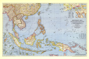
Published in October 1944 during the second world war, this map of Southeast Asia and the Pacific Islands shows boundaries as of September 1, 1939. With over twenty inset maps of islands and cities, this map provides exceptional detail of the region, including administrative areas of the Netherlands Indies and capitals. The 1944 Southeast Asia and Pacific Islands map features:
• Inset maps of Chichi Jima Retto, Eniwetok, Guam, Haha Jima Retto, Iwo Jima, Marcus, the Nansei Islands, Pagan, the Palau Islands, the Pescadores, Ponape, Pratas, Rota, Saipan and Tinian, the Truk Islands, and Yap
• Insets of major cities, including Shanghai, Hong Kong, Singapore, Soerabaja, Manila, and Davao
• The Netherland Indies administrative areas and their capitals cities
• Airfields, roads, and principal railroads including dismantled and proposed
• Mountains, river, lakes, and swamps
• Oil pipelines
• Geographical equivalents
Coverage Area: Southeast Asia, Pacific Islands from the Indies and the Philippines to the Solomons
|


 Click here to zoom!
