 |
|
|
|
|
Western Pacific Rim Map 1989
Issue: November 1989
|
|
|
|
|
|
|
| Product Highlights |
| Western Pacific Rim Map 1989 |
| Item#: X NGC 111989b |
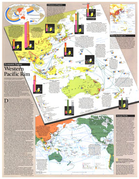
Published as a supplement to four articles including "Hanoi: The Capital Today" and the Asia-Pacific map in the November 1989 issue of National Geographic, this piece presents an abundance of information on the economic growth and development of the Western Pacific Rim. Discover the exciting changes taking place that are sure to affect the world economy in the decades to come. The Western Pacific Rim map features:
• An article on the sweeping social and economic changes taking place in the region
• Information about industries, imports, exports, government, and population trends
• Information about nuclear testing issues and oceanic nuclear test sites
• Air hubs, major sea-lanes, strategic waterways, and fiber optic communication cables
• Military facilities, communication facilities, and Western Pacific Rim disputes
• Intraregional trade partners, selected regional associations, major specialized ports, mineral resources, and principal trade commodities
• Average gross national product per capita late 1980s
Coverage Area: Western Pacific Rim
|
|
 |
More Product Details
This map requires 7 business days to print and laminate prior to shipping.
Appearing in the November 1989 issue of the National Geographic Magazine, this Western Pacific Rim map has been reproduced from its original cartography in order to bring to life a beautiful poster previously only seen in National Geographic Magazine. This reproduction holds true to the high standards that National Geographic Maps are known for.
Perfect for home, office or classroom, this map also makes a great gift. Map collectors will surely want to add this map to their library.
The Paper version is printed on high quaility semi-gloss paper, perfect for framing.
The Laminated version uses 3mm laminate on both sides for durability, is easy to clean and markable.
From the National Geographic Classic Maps collection, this reproduction is just one of hundreds of titles available here. These maps are Printed on Demand. Sizes are approximate and may vary due to the nature of the trimming and laminating processes.
|
|
Shipping Conditions
Maps.com ships to Dometic US only
 | This product can only be shipped to the Domestic U.S.A. (No APO's or PO Boxes) |  | This map requires 2 business days to print and laminate prior to shipping. |
|
|
|
|


 Click here to zoom!