SHOP BY YEAR :: FOR OFFICE :: FOR CLASSROOM :: GIFT IDEAS :: CUSTOMER SERVICE

Union Of Soviet Socialist Republics,1938-1944 Map
Issue: December 1944
More Views
Enlarge Image
ZoomClick here to zoom!
Purchase Product :
Please select map format:
Laminated   
40.5" x 26" - $59.95
Laminated-w/Plastic Rails  (What are rails?)
40.5" x 26" - $76.95
Paper
40.5" x 26" - $49.95
Wallzilla Adhesive Format
40.5" x 26" - $89.95
Product Highlights
Union Of Soviet Socialist Republics,1938-1944 Map
Item#: X NGC 121944

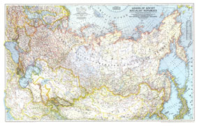
This World War II era map of the Union of Soviet Socialist Republics was published in December 1944, at the beginning of the Battle of the Bulge. International boundaries according to Russian treaties and claims as of October 1, 1944 are shown on this map, and boundaries as of January 1, 1938, before Germany invaded Poland, are noted in red.

The 1944 Union of Soviet Socialist Republics, 1938-1944 map features:
• International boundaries according to Russian treaties and claims as of October 1, 1944, and boundaries as of January 1, 1938 shown in red
• Capitals, cities, and towns
• Railways, roads, important routes, canals, winter trails, and passes
• Major rivers, major lakes, dry salt lakes, tundra, glaciers, sand deserts, and areas below sea level
• Polar stations and ruins
• Oil pipelines
• Geographical equivalents

Coverage Area: Union of Soviet Socialist Republics, Iran, Afghanistan, Romania, Hungary, Czechoslovakia, Poland, Sweden, Finland, eastern Germany, eastern Austria, northern Turkey, northern China

More Product Details

This map requires 7 business days to print and laminate prior to shipping.

Appearing in the December 1944 issue of the National Geographic Magazine, this Union Of Soviet Socialist Republics,1938-1944 map has been reproduced from its original cartography in order to bring to life a beautiful poster previously only seen in National Geographic Magazine. This reproduction holds true to the high standards that National Geographic Maps are known for.

Perfect for home, office or classroom, this map also makes a great gift. Map collectors will surely want to add this map to their library.

The Paper version is printed on high quaility semi-gloss paper, perfect for framing.

The Laminated version uses 3mm laminate on both sides for durability, is easy to clean and markable.

From the National Geographic Classic Maps collection, this reproduction is just one of hundreds of titles available here. These maps are Printed on Demand. Sizes are approximate and may vary due to the nature of the trimming and laminating processes.
Shipping Conditions
Maps.com ships to Dometic US only

US FlagThis product can only be shipped to the Domestic U.S.A. (No APO's or PO Boxes)
TimeThis map requires 2 business days to print and laminate prior to shipping.