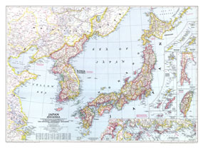
World War II had just ended when this map of Japan and Korea was published in December 1945. With the end of the war came the end of Japan's 35-year occupation of Korea. With detailed inset maps of many islands in the region, as well as a map of Tokyo, this map also contains historical notes such as the site of the Japanese surrender. The 1945 Japan and Korea map features:
• Inset maps of the Kuril Islands, the Pescadores, Karafuto, the Ryukyu Islands, Okinawa, and Formosa
• Insets of Tokyo and the location of Japan in the western Pacific
• Historical notes
• Thousands of place names including national capitals, provincial capitals, district capitals, cities and towns
• Principal railways, roads, and canals
• Geographical equivalents
• Provincial borders
Coverage Area: Japan, Korea (Chosen), southeastern China
|


 Click here to zoom!
