SHOP BY YEAR :: FOR OFFICE :: FOR CLASSROOM :: GIFT IDEAS :: CUSTOMER SERVICE

Indian Ocean Map 1941
Issue: March 1941
More Views
Enlarge Image
ZoomClick here to zoom!
Purchase Product :
Please select map format:
Laminated   
32" x 24" - $39.95
Laminated-w/Plastic Rails  (What are rails?)
32" x 24" - $51.95
Paper
32" x 24" - $29.95
Wallzilla Adhesive Format
32" x 24" - $59.95
Product Highlights
Indian Ocean Map 1941
Item#: X NGC 031941

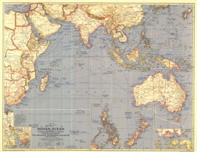
This World War II era map contains great detail about the Indian Ocean region including typical storm tracks, naval bases, and historical notes. Published in March 1941, this map is a great companion for the map of the Pacific in 1936.

The 1941 Indian Ocean map features:
• Inset maps of Guam, Hong Kong, New Zealand, the Philippines, Singapore, and the Suez Canal
• Historical and geographical notes including much about exploration and discovery in the region
• Time zone boundaries and clocks showing the time when it is midnight at Greenwich
• Depth curves, distances in nautical miles, and typical storm tracks
• Place names including capitals, cities, and towns
• Naval bases and oil fields notes
• Railways and canals

Coverage Area: Indian Ocean, Australia, New Zealand, southern Asia, eastern Africa

More Product Details

This map requires 7 business days to print and laminate prior to shipping.

Appearing in the March 1941 issue of the National Geographic Magazine, this Indian Ocean map has been reproduced from its original cartography in order to bring to life a beautiful poster previously only seen in National Geographic Magazine. This reproduction holds true to the high standards that National Geographic Maps are known for.

Perfect for home, office or classroom, this map also makes a great gift. Map collectors will surely want to add this map to their library.

The Paper version is printed on high quaility semi-gloss paper, perfect for framing.

The Laminated version uses 3mm laminate on both sides for durability, is easy to clean and markable.

From the National Geographic Classic Maps collection, this reproduction is just one of hundreds of titles available here. These maps are Printed on Demand. Sizes are approximate and may vary due to the nature of the trimming and laminating processes.
Shipping Conditions
Maps.com ships to Dometic US only

US FlagThis product can only be shipped to the Domestic U.S.A. (No APO's or PO Boxes)
TimeThis map requires 2 business days to print and laminate prior to shipping.