 |
|
|
|
|
Antarctica Map 1957
Issue: September 1957
|
|
|
|
|
|
|
| Product Highlights |
| Antarctica Map 1957 |
| Item#: X NGC 091957a |
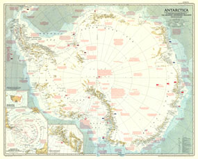
Just six months after the death of famed American polar explorer Admiral Richard E. Byrd, National Geographic Magazine published this striking map of Antarctica. A companion to the article "Year of Discovery Opens in Antarctica," this map captures the icy continent at a pivotal time in its exploration and contains a great amount of detail of both its geography and the history of the multi-national expeditions which have traversed it. The 1957 Antarctica map features:
• An abundance of information about the geography and history of Antarctic exploration
• An ice terminology key
• Insets showing relative size of Antarctica to the United States and relation of Antarctica to surrounding continents
• Detailed inset of the Queen Maud Range
• International Geophysical Year stations are identified by country
• Includes prevailing winds and sea currents
• Glaciers, ice shelfs, hummocked ice, and mountain ranges are clearly illustrated
Coverage Area: Antarctica
|
|
 |
More Product Details
This map requires 7 business days to print and laminate prior to shipping.
Appearing in the September 1957 issue of the National Geographic Magazine, this Antarctica map has been reproduced from its original cartography in order to bring to life a beautiful poster previously only seen in National Geographic Magazine. This reproduction holds true to the high standards that National Geographic Maps are known for.
Perfect for home, office or classroom, this map also makes a great gift. Map collectors will surely want to add this map to their library.
The Paper version is printed on high quaility semi-gloss paper, perfect for framing.
The Laminated version uses 3mm laminate on both sides for durability, is easy to clean and markable.
From the National Geographic Classic Maps collection, this reproduction is just one of hundreds of titles available here. These maps are Printed on Demand. Sizes are approximate and may vary due to the nature of the trimming and laminating processes.
|
|
Shipping Conditions
Maps.com ships to Dometic US only
 | This product can only be shipped to the Domestic U.S.A. (No APO's or PO Boxes) |  | This map requires 2 business days to print and laminate prior to shipping. |
|
|
|
|


 Click here to zoom!