 |
|
|
|
|
Antarctic Regions Map 1932
Issue: October 1932
|
|
|
|
|
|
|
| Product Highlights |
| Antarctic Regions Map 1932 |
| Item#: X NGC 101932 |
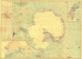
This early map of the Antarctic regions was published in October 1932, just a few years after Byrds historical flight over the South Pole. Parts of the inset maps were constructed using aerial photographs and the article "Mapping the Antarctic from the Air: The Aerial Camera Earns Its Place as the Eyes and Memory of the Explorer" appeared in the same issue of National Geographic. The 1932 Antarctic Regions map features:
• Inset map of Byrds South Pole flight
• Inset maps of King Edward VII Land and part of Marie Byrd Land, and Antarctic Archipelago
• Routes of explorers and airplane flights
• Unexplored regions
• Geographical features including mountains, glaciers and crevasses, shelf ice, sea ice, and land under perpetual snow and ice
Coverage Area: Antarctica
|
|
 |
More Product Details
This map requires 7 business days to print and laminate prior to shipping.
Appearing in the October 1932 issue of the National Geographic Magazine, this Antarctic Regions map has been reproduced from its original cartography in order to bring to life a beautiful poster previously only seen in National Geographic Magazine. This reproduction holds true to the high standards that National Geographic Maps are known for.
Perfect for home, office or classroom, this map also makes a great gift. Map collectors will surely want to add this map to their library.
The Paper version is printed on high quaility semi-gloss paper, perfect for framing.
The Laminated version uses 3mm laminate on both sides for durability, is easy to clean and markable.
From the National Geographic Classic Maps collection, this reproduction is just one of hundreds of titles available here. These maps are Printed on Demand. Sizes are approximate and may vary due to the nature of the trimming and laminating processes.
|
|
Shipping Conditions
Maps.com ships to Dometic US only
 | This product can only be shipped to the Domestic U.S.A. (No APO's or PO Boxes) |  | This map requires 2 business days to print and laminate prior to shipping. |
|
|
|
|


 Click here to zoom!