|
|
Countries Bordering The Mediterranean Sea Map 1912
Issue: January 1912

|
|
|
|
|
|
|
| Product Highlights |
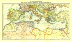
| Countries Bordering The Mediterranean Sea Map 1912 |
| Item#: X NGC 011912 |
The Map of Countries Bordering the Mediterranean Sea was published in January 1912, prior to the First Balkan War. This colorful map accompanied three articles of the region including "The Sea-Kings of Crete." The 1912 Countries Bordering the Mediterranean Sea map features:
• Steamship routes
• Principal railways
• Subtle topography illustrating elevation
• Colorful, clearly defined country borders
Coverage Area:
|
|
More Product Details
This map requires 7 business days to print and laminate prior to shipping.
Appearing in the January 1912 issue of the National Geographic Magazine, this Countries Bordering The Mediterranean Sea map has been reproduced from its original cartography in order to bring to life a beautiful poster previously only seen in National Geographic Magazine. This reproduction holds true to the high standards that National Geographic Maps are known for.
The Paper version is printed on high quaility semi-gloss paper, perfect for framing.
The Laminated version uses 3mm laminate on both sides for durability, is easy to clean and markable.
From the National Geographic Classic Maps collection, this reproduction is just one of hundreds of titles available here. These maps are Printed on Demand. Sizes are approximate and may vary due to the nature of the trimming and laminating processes.
|
|
Shipping Conditions
Maps.com ships to Dometic US only
 | This product can only be shipped to the Domestic U.S.A. (No APO's or PO Boxes) |  | This map requires 2 business days to print and laminate prior to shipping. |
|


 Click here to zoom!