SHOP BY YEAR :: FOR OFFICE :: FOR CLASSROOM :: GIFT IDEAS :: CUSTOMER SERVICE

Europe And The Near East Map 1949
Issue: June 1949
More Views
Enlarge Image
ZoomClick here to zoom!
Purchase Product :
Please select map format:
Laminated   
32" x 28" - $39.95
Laminated-w/Plastic Rails  (What are rails?)
32" x 28" - $51.95
Paper
32" x 28" - $29.95
Wallzilla Adhesive Format
32" x 28" - $59.95
Product Highlights
Europe And The Near East Map 1949
Item#: X NGC 061949

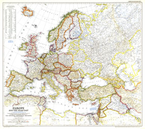
A striking rendering of post-war Europe, this map is unique in its lack of ocean color. Colorful borders leap off the white page projecting an optimistic tone. Published in June 1949 with the article "Italy Smiles Again," this map shows American, British, French, and Russian occupational zones in Germany and Austria.

The 1949 Europe and the Near East map features:
• Thousands of place names including capitals, cities, and towns
• Colorful and boldly drawn borders
• Allied occupation zones in Germany and Austria during World War II
• Mountains, rivers, lakes, dry salt lakes, swamps, wadies, deserts, and areas below sea level
• Principal railways and canals
• Oil fields, oil pipelines, and pumping stations
• Geographical equivalents

Coverage Area: Europe, western USSR, Turkey, Syria, Iraq, Transjordan, Lebanon, Israel, Kuwait, Tunisia

More Product Details

This map requires 7 business days to print and laminate prior to shipping.

Appearing in the June 1949 issue of the National Geographic Magazine, this Europe And The Near East map has been reproduced from its original cartography in order to bring to life a beautiful poster previously only seen in National Geographic Magazine. This reproduction holds true to the high standards that National Geographic Maps are known for.

Perfect for home, office or classroom, this map also makes a great gift. Map collectors will surely want to add this map to their library.

The Paper version is printed on high quaility semi-gloss paper, perfect for framing.

The Laminated version uses 3mm laminate on both sides for durability, is easy to clean and markable.

From the National Geographic Classic Maps collection, this reproduction is just one of hundreds of titles available here. These maps are Printed on Demand. Sizes are approximate and may vary due to the nature of the trimming and laminating processes.
Shipping Conditions
Maps.com ships to Dometic US only

US FlagThis product can only be shipped to the Domestic U.S.A. (No APO's or PO Boxes)
TimeThis map requires 2 business days to print and laminate prior to shipping.