SHOP BY YEAR :: FOR OFFICE :: FOR CLASSROOM :: GIFT IDEAS :: CUSTOMER SERVICE

Middle East Map 1991
Issue: February 1991
More Views
Enlarge Image
ZoomClick here to zoom!
Purchase Product :
Please select map format:
Laminated   
20" x 24.5" - $19.95
Laminated-w/Plastic Rails  (What are rails?)
20" x 24.5" - $29.95
Paper
20" x 24.5" - $14.95
Wallzilla Adhesive Format
20" x 24.5" - $34.95
Product Highlights
Middle East Map 1991
Item#: X NGC 021991a

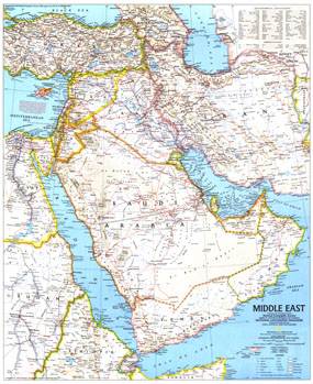
The Middle East map was published in February 1991 during the Gulf War. It accompanied "The Middle East: States in Turmoil" map. With a variety of geographical features, extensive transportation details, and such sites as ruins and oil fields noted, this is a fine example of the detailed cartography National Geographic is known for.

The 1991 Middle East map features:
• Capitals, cities, and towns
• Areas of intermittent drainage
• Mountains, passes, rivers, lakes, water holes, swamps, sand, volcanic debris, and areas below sea level
• Roads, railroads, canals, and airports
• Ruins, craters, and oil fields
• Geographical equivalents

Coverage Area: Iran, Iraq, Kuwait, Bahrain, Qatar, United Arab Emirates, Oman, Yemen, Saudi Arabia, Israel, Lebanon, Jordan, Cyprus, Djibouti, eastern Egypt, southern Turkey, northern Ethiopia, eastern Sudan

More Product Details

This map requires 7 business days to print and laminate prior to shipping.

Appearing in the February 1991 issue of the National Geographic Magazine, this Middle East map has been reproduced from its original cartography in order to bring to life a beautiful poster previously only seen in National Geographic Magazine. This reproduction holds true to the high standards that National Geographic Maps are known for.

Perfect for home, office or classroom, this map also makes a great gift. Map collectors will surely want to add this map to their library.

The Paper version is printed on high quaility semi-gloss paper, perfect for framing.

The Laminated version uses 3mm laminate on both sides for durability, is easy to clean and markable.

From the National Geographic Classic Maps collection, this reproduction is just one of hundreds of titles available here. These maps are Printed on Demand. Sizes are approximate and may vary due to the nature of the trimming and laminating processes.
Shipping Conditions
Maps.com ships to Dometic US only

US FlagThis product can only be shipped to the Domestic U.S.A. (No APO's or PO Boxes)
TimeThis map requires 2 business days to print and laminate prior to shipping.