SHOP BY YEAR :: FOR OFFICE :: FOR CLASSROOM :: GIFT IDEAS :: CUSTOMER SERVICE

Peoples Of The Middle East Map 1972 Side 2
Issue: July 1972
More Views
Enlarge Image
ZoomClick here to zoom!
Purchase Product :
Please select map format:
Laminated   
35.5" x 22.5" - $39.95
Laminated-w/Plastic Rails  (What are rails?)
35.5" x 22.5" - $51.95
Paper
35.5" x 22.5" - $29.95
Wallzilla Adhesive Format
35.5" x 22.5" - $59.95
Product Highlights
Peoples Of The Middle East Map 1972 Side 2
Item#: X NGC 071972b

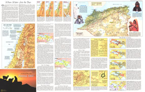
Half of a two-map set, the Peoples of the Middle East map is filled with a wealth of information about the region and its inhabitants including their work, religions, languages, the role of women, politics, and more. Published in July 1972, this map contains over a dozen maps detailing historical periods, religious sites, land use, and ethnic groups.

The 1972 Peoples of the Middle East map side 2 features:
• Informative inset map of the Holy Land today
• An article covering many aspects of the region including religion, city life, farming, oil, and a section on the birthplace of the alphabet
• Four inset maps of Palestine and Israel detailing the troubled history of the region
• Five maps showing the ebb and flow of empires from early civilizations through European imperialism
• Maps showing land use and religions of the region
• Map of the walled city of Jerusalem
• Map and information on the sacred pilgrimage, the Hajj, from Mecca to Arafat

Coverage Area: The Middle East

More Product Details

This map requires 7 business days to print and laminate prior to shipping.

Appearing in the July 1972 issue of the National Geographic Magazine, this Peoples Of The Middle East map has been reproduced from its original cartography in order to bring to life a beautiful poster previously only seen in National Geographic Magazine. This reproduction holds true to the high standards that National Geographic Maps are known for.

Perfect for home, office or classroom, this map also makes a great gift. Map collectors will surely want to add this map to their library.

The Paper version is printed on high quaility semi-gloss paper, perfect for framing.

The Laminated version uses 3mm laminate on both sides for durability, is easy to clean and markable.

From the National Geographic Classic Maps collection, this reproduction is just one of hundreds of titles available here. These maps are Printed on Demand. Sizes are approximate and may vary due to the nature of the trimming and laminating processes.
Shipping Conditions
Maps.com ships to Dometic US only

US FlagThis product can only be shipped to the Domestic U.S.A. (No APO's or PO Boxes)
TimeThis map requires 2 business days to print and laminate prior to shipping.