SHOP BY YEAR :: FOR OFFICE :: FOR CLASSROOM :: GIFT IDEAS :: CUSTOMER SERVICE

Middle East Map 1978
Issue: September 1978
More Views
Enlarge Image
ZoomClick here to zoom!
Purchase Product :
Please select map format:
Laminated   
37" x 23" - $59.95
Laminated-w/Plastic Rails  (What are rails?)
37" x 23" - $76.95
Paper
37" x 23" - $49.95
Wallzilla Adhesive Format
37" x 23" - $89.95
Product Highlights
Middle East Map 1978
Item#: X NGC 091978a

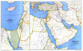
Israel had occupied the West Bank, Sinai Peninsula, and Golan Heights for over a decade when this map of the Middle East was published in September 1978, but six months later, after the signing of the Israel-Egypt Peace Treaty, Israel would withdraw from the Sinai Peninsula and evacuate the settlements it had established there during the 1970s. The "Early Civilizations in the Middle East" map was printed in the same issue as a companion to this map.

The 1978 Middle East map features:
• Inset map of the Eastern Mediterranean showing areas occupied by Israel
• Capitals, cities, and towns
• Roads, railroads, canals, and airports
• Mountains, rivers, lakes, water holes, swamps, deserts, volcanic debris, and areas below sea level
• Passes, ruins, craters, oil fields, and points of interest
• Geographical equivalents

Coverage Area: Greece, Turkey, Iran, Iraq, Syria, Lebanon, Israel, Jordan, Kuwait, Bahrain, United Arab Emirates, Saudi Arabia, Yemen, Democratic Yemen, Egypt, Sudan, northern Ethiopia

More Product Details

This map requires 7 business days to print and laminate prior to shipping.

Appearing in the September 1978 issue of the National Geographic Magazine, this Middle East map has been reproduced from its original cartography in order to bring to life a beautiful poster previously only seen in National Geographic Magazine. This reproduction holds true to the high standards that National Geographic Maps are known for.

Perfect for home, office or classroom, this map also makes a great gift. Map collectors will surely want to add this map to their library.

The Paper version is printed on high quaility semi-gloss paper, perfect for framing.

The Laminated version uses 3mm laminate on both sides for durability, is easy to clean and markable.

From the National Geographic Classic Maps collection, this reproduction is just one of hundreds of titles available here. These maps are Printed on Demand. Sizes are approximate and may vary due to the nature of the trimming and laminating processes.
Shipping Conditions
Maps.com ships to Dometic US only

US FlagThis product can only be shipped to the Domestic U.S.A. (No APO's or PO Boxes)
TimeThis map requires 2 business days to print and laminate prior to shipping.