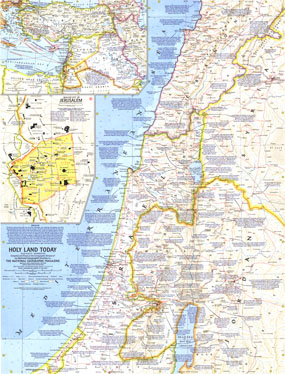
Published in December 1963 with two articles on the region, "Crusader Road to Jerusalem" and "Conquest of the Holy City," this map of the Holy Land provides crisp detail and an abundance of historical notes. An inset map of the Middle East shows Crusade routes and the Walled City of Jerusalem map reveals the fourteen stations marking the way of the cross from Pilates hall to Calvary. The 1963 Holy Land Today map features:
• Walled City of Jerusalem inset with the way of the cross from Pilates hall of judgment to Calvary
• Inset of the Middle East showing the Crusade routes
• Copious historical information with notes referencing revelant Biblical passages
• An abundance of place names including capitals, cities, and towns
• Roads, railroads, and places with scheduled air service
• Coastal bathymetry and geographical details including mountains, lakes, rivers, deserts, lava, water holes, and areas below sea level
• Oil fields and pipelines
Coverage Area: Israel, western Jordan, southern Lebanon, western Syria
|


 Click here to zoom!
