SHOP BY YEAR :: FOR OFFICE :: FOR CLASSROOM :: GIFT IDEAS :: CUSTOMER SERVICE

Countries Of The Caribbean Map 1922
Issue: February 1922
More Views
Enlarge Image
ZoomClick here to zoom!
Purchase Product :
Please select map format:
Laminated   
44" x 25" - $59.95
Laminated-w/Plastic Rails  (What are rails?)
44" x 25" - $76.95
Paper
44" x 25" - $49.95
Wallzilla Adhesive Format
44" x 25" - $89.95
Product Highlights
Countries Of The Caribbean Map 1922
Item#: X NGC 021922

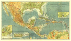
This beautiful map of the Caribbean includes Central America, the West Indies, and Mexico. Published in February 1922, this map appeared in an issue entirely devoted to Middle America. Rich color, and details such as inset maps, steamship routes, and wireless stations, make this piece a fine map for collectors.

The 1922 Countries of the Caribbean map features:
• Inset maps of Guantanamo Bay, Porto Rico and the Virgin Islands, and the Panama Canal
• Steamship routes with distances in nautical miles
• Head of navigation, wireless stations, U.S. Consular offices and agencies
• Cities, towns, and capitals including country capitals, state capitals, colonial capitals, and provincial capitals
• Highways and railroads, including railroads under construction
• Color variations demonstrate elevation of land and depth of ocean
• Boundaries of countries, states, and provinces

Coverage Area: Caribbean, Mexico, Central America, West Indies

More Product Details

This map requires 7 business days to print and laminate prior to shipping.

Appearing in the February 1922 issue of the National Geographic Magazine, this Countries Of The Caribbean map has been reproduced from its original cartography in order to bring to life a beautiful poster previously only seen in National Geographic Magazine. This reproduction holds true to the high standards that National Geographic Maps are known for.

Perfect for home, office or classroom, this map also makes a great gift. Map collectors will surely want to add this map to their library.

The Paper version is printed on high quaility semi-gloss paper, perfect for framing.

The Laminated version uses 3mm laminate on both sides for durability, is easy to clean and markable.

From the National Geographic Classic Maps collection, this reproduction is just one of hundreds of titles available here. These maps are Printed on Demand. Sizes are approximate and may vary due to the nature of the trimming and laminating processes.
Shipping Conditions
Maps.com ships to Dometic US only

US FlagThis product can only be shipped to the Domestic U.S.A. (No APO's or PO Boxes)
TimeThis map requires 2 business days to print and laminate prior to shipping.