SHOP BY YEAR :: FOR OFFICE :: FOR CLASSROOM :: GIFT IDEAS :: CUSTOMER SERVICE

West Indies And Central America Map 1981
Issue: February 1981
More Views
Enlarge Image
ZoomClick here to zoom!
Purchase Product :
Please select map format:
Laminated   
33.5" x 22.5" - $39.95
Laminated-w/Plastic Rails  (What are rails?)
33.5" x 22.5" - $51.95
Paper
33.5" x 22.5" - $29.95
Wallzilla Adhesive Format
33.5" x 22.5" - $59.95
Product Highlights
West Indies And Central America Map 1981
Item#: X NGC 021981a

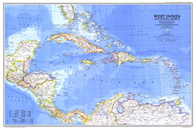
In the Caribbean, the 1980s were marked by political unrest in Haiti and Grenada and economic difficulties in Jamaica. Half of a two-map set, the West Indies and Central America map was published in National Geographic Magazine in February 1981 with two articles, "The U.S. Virgin Islands" and "The Caribbean: Sun, Sea, and Seething."

The 1981 West Indies and Central America map features:
• Political adminstration of the islands
• Capitals, cities, and towns
• Pan American highway, roads, railroads, canals, and airports
• Ocean bathymetry, mountains, rivers, lakes, and swamps
• Ruins and sites
• Oil fields and pipelines
• Geographical equivalents

Coverage Area: West Indies, Central America, northern Columbia, northern Venezuela

More Product Details

This map requires 7 business days to print and laminate prior to shipping.

Appearing in the February 1981 issue of the National Geographic Magazine, this West Indies And Central America map has been reproduced from its original cartography in order to bring to life a beautiful poster previously only seen in National Geographic Magazine. This reproduction holds true to the high standards that National Geographic Maps are known for.

Perfect for home, office or classroom, this map also makes a great gift. Map collectors will surely want to add this map to their library.

The Paper version is printed on high quaility semi-gloss paper, perfect for framing.

The Laminated version uses 3mm laminate on both sides for durability, is easy to clean and markable.

From the National Geographic Classic Maps collection, this reproduction is just one of hundreds of titles available here. These maps are Printed on Demand. Sizes are approximate and may vary due to the nature of the trimming and laminating processes.
Shipping Conditions
Maps.com ships to Dometic US only

US FlagThis product can only be shipped to the Domestic U.S.A. (No APO's or PO Boxes)
TimeThis map requires 2 business days to print and laminate prior to shipping.