 |
|
|
|
|
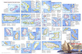
Tourist Islands Of The West Indies Map 1981
Issue: February 1981
|
|
|
|
|
|
|
| Product Highlights |
| Tourist Islands Of The West Indies Map 1981 |
| Item#: X NGC 021981b |
Featuring maps and information on over thirty islands in the Caribbean, the Tourist Islands of the West Indies map is half of a two-map set highlighting the unique tourist destinations to be found in the region. Published in National Geographic Magazine in February 1981, it accompanied the West Indies and Central America map. The 1981 Tourist Islands of the West Indies map features:
• Maps of over thirty islands
• Information about the history, geography, and tourist activities to be found on the islands
• Cities and towns
• Mountains, lakes, and reefs
• Ocean bathymetry
• Roads and airports
Coverage Area: West Indies
|
|
 |
More Product Details
This map requires 7 business days to print and laminate prior to shipping.
Appearing in the February 1981 issue of the National Geographic Magazine, this Tourist Islands Of The West Indies map has been reproduced from its original cartography in order to bring to life a beautiful poster previously only seen in National Geographic Magazine. This reproduction holds true to the high standards that National Geographic Maps are known for.
Perfect for home, office or classroom, this map also makes a great gift. Map collectors will surely want to add this map to their library.
The Paper version is printed on high quaility semi-gloss paper, perfect for framing.
The Laminated version uses 3mm laminate on both sides for durability, is easy to clean and markable.
From the National Geographic Classic Maps collection, this reproduction is just one of hundreds of titles available here. These maps are Printed on Demand. Sizes are approximate and may vary due to the nature of the trimming and laminating processes.
|
|
Shipping Conditions
Maps.com ships to Dometic US only
 | This product can only be shipped to the Domestic U.S.A. (No APO's or PO Boxes) |  | This map requires 2 business days to print and laminate prior to shipping. |
|
|
|
|


 Click here to zoom!