 |
|
|
|
|
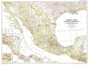
Mexico And Central America Map 1953
Issue: March 1953
|
|
|
|
|
|
|
| Product Highlights |
| Mexico And Central America Map 1953 |
| Item#: X NGC 031953 |
This map is unique in that it combines Mexico and Central America, showing the expansion of transportation in the region as roads and parts of the Pan American Highway were being built. At the time of this publication in March 1953, many regions of Central America relied on air travel as the principal means of modern transportation. Honduras in particular had more airports that roadways. The 1953 Mexico and Central America map features:
• Detailed inset of the Panama Canal Zone
• Guadalupe Island and the Revilla Gigedo Islands
• Thousands of place names including capitals, cities, and towns
• Pan American highway, principal railways, roads, principal airports, and canals
• Geographical features including mountains, rivers, and lakes
• Geographical equivalents and abbreviations
• Colorful national borders
Coverage Area: Mexico, Central America
|
|
 |
More Product Details
This map requires 7 business days to print and laminate prior to shipping.
Appearing in the March 1953 issue of the National Geographic Magazine, this Mexico And Central America map has been reproduced from its original cartography in order to bring to life a beautiful poster previously only seen in National Geographic Magazine. This reproduction holds true to the high standards that National Geographic Maps are known for.
Perfect for home, office or classroom, this map also makes a great gift. Map collectors will surely want to add this map to their library.
The Paper version is printed on high quaility semi-gloss paper, perfect for framing.
The Laminated version uses 3mm laminate on both sides for durability, is easy to clean and markable.
From the National Geographic Classic Maps collection, this reproduction is just one of hundreds of titles available here. These maps are Printed on Demand. Sizes are approximate and may vary due to the nature of the trimming and laminating processes.
|
|
Shipping Conditions
Maps.com ships to Dometic US only
 | This product can only be shipped to the Domestic U.S.A. (No APO's or PO Boxes) |  | This map requires 2 business days to print and laminate prior to shipping. |
|
|
|
|


 Click here to zoom!