SHOP BY YEAR :: FOR OFFICE :: FOR CLASSROOM :: GIFT IDEAS :: CUSTOMER SERVICE

West Indies Map 1954
Issue: March 1954
More Views
Enlarge Image
ZoomClick here to zoom!
Purchase Product :
Please select map format:
Laminated   
37" x 29" - $59.95
Laminated-w/Plastic Rails  (What are rails?)
37" x 29" - $76.95
Paper
37" x 29" - $49.95
Wallzilla Adhesive Format
37" x 29" - $89.95
Product Highlights
West Indies Map 1954
Item#: X NGC 031954

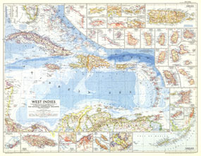
Published in March 1954, this colorful map of the West Indies contains thirty inset maps providing spectacular detail of the many islands in the Caribbean. Two articles, "Jamaica - Hub of the Caribbean" and "Night Life in the Gulf Stream," appeared in the same issue, highlighting this fascinating and culturally rich tropical region.

The 1954 West Indies map features:
• Thirty inset maps of islands, the Panama Canal zone, and the Florida Keys
• Capitals, cities, and towns
• Pan American highway, roads, principal railroads, canals, and principal airports
• Mountain relief, rivers, swampy regions, and reefs
• Ocean bathymetry, currents, and prevailing winds
• Ruins
• Oil fields and pipelines

Coverage Area: West Indies, Florida Keys, Costa Rica, Panama, northern Columbia, northern Venezuela

More Product Details

This map requires 7 business days to print and laminate prior to shipping.

Appearing in the March 1954 issue of the National Geographic Magazine, this West Indies map has been reproduced from its original cartography in order to bring to life a beautiful poster previously only seen in National Geographic Magazine. This reproduction holds true to the high standards that National Geographic Maps are known for.

Perfect for home, office or classroom, this map also makes a great gift. Map collectors will surely want to add this map to their library.

The Paper version is printed on high quaility semi-gloss paper, perfect for framing.

The Laminated version uses 3mm laminate on both sides for durability, is easy to clean and markable.

From the National Geographic Classic Maps collection, this reproduction is just one of hundreds of titles available here. These maps are Printed on Demand. Sizes are approximate and may vary due to the nature of the trimming and laminating processes.
Shipping Conditions
Maps.com ships to Dometic US only

US FlagThis product can only be shipped to the Domestic U.S.A. (No APO's or PO Boxes)
TimeThis map requires 2 business days to print and laminate prior to shipping.