SHOP BY YEAR :: FOR OFFICE :: FOR CLASSROOM :: GIFT IDEAS :: CUSTOMER SERVICE

Making Of America, Atlantic Gateways Map 1983
Issue: March 1983
More Views
Enlarge Image
ZoomClick here to zoom!
Purchase Product :
Please select map format:
     All versions of this item are currently out of stock.
     Availability is approximately 2 weeks.
Product Highlights
Making Of America, Atlantic Gateways Map 1983
Item#: X NGC 031983a

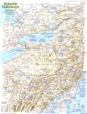
Explore the central states on the eastern seaboard with this educational map of the Atlantic Gateways. Published in March 1983 as part of the "Making of America" series, this map is Side One of a two map set. From the early settlements of European colonists to the great cities of New York, Philadelphia, and Washington, D.C., this vital region has a tremendous historical and modern day presence.

The 1983 Atlantic Gateways map Side 1 features:
• An abundance of historical notes
• US national parks, Canadian national parks, Indian reservations or reserves, ruins, sites, and battlefields
• State and provincial capitals, cities, and towns
• Mountain relief, passes, rivers, and lakes
• Interstate highways, roads, railroads, canals, ferry routes, and scheduled air service
• Mining areas and oil fields
• Geographical equivalents

Coverage Area: New York, Pennsylvania, New Jersey, Maryland, West Virginia, Virginia, southern Ontario

More Product Details

This map requires 7 business days to print and laminate prior to shipping.

Appearing in the March 1983 issue of the National Geographic Magazine, this Atlantic Gateways map Side 1 has been reproduced from its original cartography in order to bring to life a beautiful poster previously only seen in National Geographic Magazine. This reproduction holds true to the high standards that National Geographic Maps are known for.

Perfect for home, office or classroom, this map also makes a great gift. Map collectors will surely want to add this map to their library.

The Paper version is printed on high quaility semi-gloss paper, perfect for framing.

The Laminated version uses 3mm laminate on both sides for durability, is easy to clean and markable.

From the National Geographic Classic Maps collection, this reproduction is just one of hundreds of titles available here. These maps are Printed on Demand. Sizes are approximate and may vary due to the nature of the trimming and laminating processes.
Shipping Conditions
Maps.com ships to Dometic US only

US FlagThis product can only be shipped to the Domestic U.S.A. (No APO's or PO Boxes)
TimeThis map requires 2 business days to print and laminate prior to shipping.