SHOP BY YEAR :: FOR OFFICE :: FOR CLASSROOM :: GIFT IDEAS :: CUSTOMER SERVICE

Making Of America, Atlantic Gateways Map 1983
Issue: March 1983
More Views
Enlarge Image
ZoomClick here to zoom!
Purchase Product :
Please select map format:
     All versions of this item are currently out of stock.
     Availability is approximately 2 weeks.
Product Highlights
Making Of America, Atlantic Gateways Map 1983
Item#: X NGC 031983b

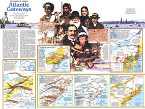
Part of the "Making of America" series, this map of the Atlantic Gateways is Side Two of a two-map set. Published in March 1983, this work features an abundance of historical information about the central region of the eastern seaboard including New York, Pennsylvania, New Jersey, Maryland, Rhode Island, northern Virginia, and southern Massachusetts.

The 1983 Atlantic Gateways map Side 2 features:
• An introduction and historical overview
• The Indians and Trade map (1600-1760) showing tribes, paths, migrations, forts, and explorers' routes
• A map detailing immigration to the region including the ethnicities of early settlements and the influx of other ethnicities post 1830
• The Race to the Hinterlands map from 1800-1840 showing movement corridors, canals, railroads, and roads
• A map detailing the growth of industry from 1840-1910 which includes iron and steel centers, coal, manufacturing centers, and more
• A map of urban expansion in the region from 1945 to present
• Colorful illustrations

Coverage Area: New York, Pennsylvania, New Jersey, Maryland, West Virginia, Virginia, New Hampshire, Vermont, Rhode Island, southern Massachusetts, southern Ontario

More Product Details

This map requires 7 business days to print and laminate prior to shipping.

Appearing in the March 1983 issue of the National Geographic Magazine, this Atlantic Gateways map Side 2 has been reproduced from its original cartography in order to bring to life a beautiful poster previously only seen in National Geographic Magazine. This reproduction holds true to the high standards that National Geographic Maps are known for.

Perfect for home, office or classroom, this map also makes a great gift. Map collectors will surely want to add this map to their library.

The Paper version is printed on high quaility semi-gloss paper, perfect for framing.

The Laminated version uses 3mm laminate on both sides for durability, is easy to clean and markable.

From the National Geographic Classic Maps collection, this reproduction is just one of hundreds of titles available here. These maps are Printed on Demand. Sizes are approximate and may vary due to the nature of the trimming and laminating processes.
Shipping Conditions
Maps.com ships to Dometic US only

US FlagThis product can only be shipped to the Domestic U.S.A. (No APO's or PO Boxes)
TimeThis map requires 2 business days to print and laminate prior to shipping.