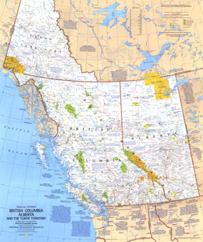
Half of a two-map set, this map of British Columbia, Alberta and the Yukon Territory is a wonderful travel map with points of interest in tourist destinations such as Vancouver, Victoria, Edmonton, and Dawson, as well as hundreds of national parks, wilderness areas, campgrounds, and ski resorts. Published in April 1978, its companion map features additional information on these beautiful provinces. The 1978 Canada, British Columbia, Alberta and the Yukon Territory map features:
• A list of sites and events in many tourist destinations
• Ski areas and points of interest
• Indian reserves, national parks, national game reserves, wilderness areas, and provincial and territorial parks, campgrounds and historic sites
• Capitals, cities, and towns
• Roads, passenger railroads, ferry routes, and airports
• Mountains, rivers, lakes, swamps, and drainage divides
• Inside passage noted
Coverage Area: British Columbia, Alberta, Yukon Territory
|


 Click here to zoom!
