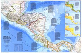
This colorful map of Central America features a unique overview of each country including such details as size, population, religion, language, and more. Published in April 1986, it is half of a two-map set which includes the "Central America Past and Present" map. The 1986 Central America map features:
• Information on each country including size, population, capital, religion, language, literacy, life expectancy, economy, and per capita income
• A map showing the land use of the region
• Maps of ethnic distribution and population density
• Capitals, cities, and towns
• Ruins, sites, oil fields, and oil pipelines
• Pan-American highway system, roads, passenger railroads, and scheduled air service
• Ocean bathymetry, mountains, rivers, lakes, swamps, and reefs
Coverage Area: Central America
|


 Click here to zoom!
