 |
|
|
|
|
Central America Map 1986
Issue: April 1986
|
|
|
|
|
|
|
| Product Highlights |
| Central America Map 1986 |
| Item#: X NGC 041986b |
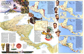
Half of a two-map set, this map of "Central America Past and Present" accompanied the political map of Central America that appeared in the same issue. Published in April 1986, this educational map features six individual maps highlighting the history of the region and colorful illustrations of historical figures, artifacts, and wildlife. The 1986 Central America Past and Present map features:
• A geographical and historical overview
• Early trade routes, commodities traded, and historical sites
• Map of the conquest and colonization of the region
• A Time of Independence map showing the region in colonial times from 1821-1900
• The Prelude to Change map (1900-1945) showing the products of the region, migration routes, and shipping routes
• A present day map featuring the variety of resources of the region including banana and fruit, cacao, coffee, corn, cattle, fish, tobacco, oil, and more
• Illustrations of historical figures, artifacts, and wildlife
Coverage Area: Central America
|
|
 |
More Product Details
This map requires 7 business days to print and laminate prior to shipping.
Appearing in the April 1986 issue of the National Geographic Magazine, this Central America Past and Present map has been reproduced from its original cartography in order to bring to life a beautiful poster previously only seen in National Geographic Magazine. This reproduction holds true to the high standards that National Geographic Maps are known for.
Perfect for home, office or classroom, this map also makes a great gift. Map collectors will surely want to add this map to their library.
The Paper version is printed on high quaility semi-gloss paper, perfect for framing.
The Laminated version uses 3mm laminate on both sides for durability, is easy to clean and markable.
From the National Geographic Classic Maps collection, this reproduction is just one of hundreds of titles available here. These maps are Printed on Demand. Sizes are approximate and may vary due to the nature of the trimming and laminating processes.
|
|
Shipping Conditions
Maps.com ships to Dometic US only
 | This product can only be shipped to the Domestic U.S.A. (No APO's or PO Boxes) |  | This map requires 2 business days to print and laminate prior to shipping. |
|
|
|
|


 Click here to zoom!