SHOP BY YEAR :: FOR OFFICE :: FOR CLASSROOM :: GIFT IDEAS :: CUSTOMER SERVICE

Northwestern United States and Canadian Provinces Map 1950
Issue: June 1950
More Views
Enlarge Image
ZoomClick here to zoom!
Purchase Product :
Please select map format:
Laminated   
36" x 25.5" - $39.95
Laminated-w/Plastic Rails  (What are rails?)
36" x 25.5" - $51.95
Paper
36" x 25.5" - $29.95
Wallzilla Adhesive Format
36" x 25.5" - $59.95
Product Highlights
Northwestern United States and Canadian Provinces Map 1950
Item#: X NGC 061950

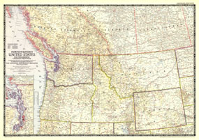
The Northwestern United States and Neighboring Canadian Provinces map is the sixth in a series of sectional maps of the United States dated from 1945 to 1950. Published in June 1950, it provides a thorough look at the states of Washington, Oregon, Idaho, Montana, and Wyoming, as well as the southern portions of British Columbia, Alberta, and Saskatchewan.

The 1950 Northwestern United States and Neighboring Canadian Provinces map features:
• A list of the titles and publication dates of the six maps in the series
• Inset of the Puget Sound region
• State capitals, cities, and towns
• Principal railways, highways, and airports
• Mountain ranges, major rivers, and major lakes

Coverage Area: Washington, Oregon, Idaho, Montana, Wyoming, southern British Columbia, southern Alberta, southern Saskatchewan

More Product Details

This map requires 7 business days to print and laminate prior to shipping.

Appearing in the June 1950 issue of the National Geographic Magazine, this Northwestern United States and Neighboring Canadian Provinces map has been reproduced from its original cartography in order to bring to life a beautiful poster previously only seen in National Geographic Magazine. This reproduction holds true to the high standards that National Geographic Maps are known for.

Perfect for home, office or classroom, this map also makes a great gift. Map collectors will surely want to add this map to their library.

The Paper version is printed on high quaility semi-gloss paper, perfect for framing.

The Laminated version uses 3mm laminate on both sides for durability, is easy to clean and markable.

From the National Geographic Classic Maps collection, this reproduction is just one of hundreds of titles available here. These maps are Printed on Demand. Sizes are approximate and may vary due to the nature of the trimming and laminating processes.
Shipping Conditions
Maps.com ships to Dometic US only

US FlagThis product can only be shipped to the Domestic U.S.A. (No APO's or PO Boxes)
TimeThis map requires 2 business days to print and laminate prior to shipping.