 |
|
|
|
|
Vacationlands Of The United States And Canada Map 1966
Issue: July 1966
|
|
|
|
|
|
|
| Product Highlights |
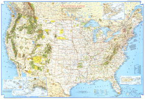
| Vacationlands Of The United States And Canada Map 1966 |
| Item#: X NGC 071966a |
Discover the abundance of diverse recreational sites the United States and Canada have to offer with this detailed map. Published in 1966 with four articles on the United States National Parks, this map was supplemented by the "Enjoying Our Scenic Treasures and Historical Sites" map which appeared in the same issue. The 1966 Vacationlands of the United States and Canada map features:
• Hundred of vacation sites including national parks, national or provincial forests, Indian reservations, wildlife refuges, recreational and historical parks, and ski areas
• Inset maps of the principal Hawaiian Islands and Puerto Rico and the Virgin Islands
• Map of the area east of Maine including New Brunswick, Nova Scotia, and Prince Edward Island
• Capitals, cities, and towns
• Geographical features including mountains, rivers, lakes, deserts, swamps, glaciers, and more
• Superhighways, roads, intercoastal waterways, and canals
Coverage Area: United States, southern Canada
|
|
 |
More Product Details
This map requires 7 business days to print and laminate prior to shipping.
Appearing in the July 1966 issue of the National Geographic Magazine, this Vacationlands Of The United States And Canada map has been reproduced from its original cartography in order to bring to life a beautiful poster previously only seen in National Geographic Magazine. This reproduction holds true to the high standards that National Geographic Maps are known for.
Perfect for home, office or classroom, this map also makes a great gift. Map collectors will surely want to add this map to their library.
The Paper version is printed on high quaility semi-gloss paper, perfect for framing.
The Laminated version uses 3mm laminate on both sides for durability, is easy to clean and markable.
From the National Geographic Classic Maps collection, this reproduction is just one of hundreds of titles available here. These maps are Printed on Demand. Sizes are approximate and may vary due to the nature of the trimming and laminating processes.
|
|
Shipping Conditions
Maps.com ships to Dometic US only
 | This product can only be shipped to the Domestic U.S.A. (No APO's or PO Boxes) |  | This map requires 2 business days to print and laminate prior to shipping. |
|
|
|
|


 Click here to zoom!