 |
|
|
|
|
Enjoying Our Scenic Treasures and Historical Sites 1966
Issue: July 1966
|
|
|
|
|
|
|
| Product Highlights |
| Enjoying Our Scenic Treasures and Historical Sites 1966 |
| Item#: X NGC 071966b |
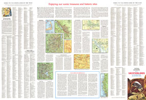
A supplement to the Vacationlands of the United States and Canada map, this map includes tips on vacationing and maps of some popular sites. Published in July 1966, it contains information on the variety of scenic and historical sites, from the lure of Indian lands and places where wildlife roam to landmarks of city and industry. The 1966 Enjoying Our Scenic Treasures and Historical Sites 1966 map features:
• A complete index for the Vacationlands of the United States and Canada map
• Inset maps of Yellowstone, Cape Cod, Banff, Mesa Verde, and the Adirondack State Forest Preserve
• Maps of Navajo Country and the Redwood Empire
• City maps of colonial Williamsburg and the tourist area of Washington D.C.
• Tips on camping and traveling by car
• Where to write for vacation information
• How map and index help you plan your trip
Coverage Area: United States, southern Canada
|
|
 |
More Product Details
This map requires 7 business days to print and laminate prior to shipping.
Appearing in the July 1966 issue of the National Geographic Magazine, this Enjoying Our Scenic Treasures and Historical Sites map has been reproduced from its original cartography in order to bring to life a beautiful poster previously only seen in National Geographic Magazine. This reproduction holds true to the high standards that National Geographic Maps are known for.
Perfect for home, office or classroom, this map also makes a great gift. Map collectors will surely want to add this map to their library.
The Paper version is printed on high quaility semi-gloss paper, perfect for framing.
The Laminated version uses 3mm laminate on both sides for durability, is easy to clean and markable.
From the National Geographic Classic Maps collection, this reproduction is just one of hundreds of titles available here. These maps are Printed on Demand. Sizes are approximate and may vary due to the nature of the trimming and laminating processes.
|
|
Shipping Conditions
Maps.com ships to Dometic US only
 | This product can only be shipped to the Domestic U.S.A. (No APO's or PO Boxes) |  | This map requires 2 business days to print and laminate prior to shipping. |
|
|
|
|


 Click here to zoom!