 |
|
|
|
|
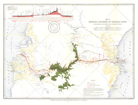
Map Showing Location of Panama Canal 1899-1902
Issue: October 1905
|
|
|
|
|
|
|
| Product Highlights |
| Map Showing Location of Panama Canal 1899-1902 |
| Item#: X NGC 101905 |
The "Map Showing Location of Panama Canal, as Recommended by the Isthmian Canal Commission of 1899-1902" is a unique historical piece published in October 1905 with three articles on canals. One of the largest engineering projects ever undertaken, the famed canal linking the Atlantic and Pacific oceans was completed in 1914. This map makes a fine companion for the "Birds-eye View of the Panama Canal" map printed in 1912. The 1905 Map Showing Location of Panama Canal, as Recommended by the Isthmian Canal Commission of 1899-1902 features:
• Profile of the canal
• Panama railroad and proposed diversion of railroad
• River diversion
• Selected cities and towns
• Mountain relief, rivers, lakes, and swampy regions
• Locks
• Depths in Limon Bay and the Bay of Panama
Coverage Area: Panama Canal
|
|
 |
More Product Details
This map requires 7 business days to print and laminate prior to shipping.
Appearing in the October 1905 issue of the National Geographic Magazine, this map Showing Location of Panama Canal, as Recommended by the Isthmian Canal Commission of 1899-1902 has been reproduced from its original cartography in order to bring to life a beautiful poster previously only seen in National Geographic Magazine. This reproduction holds true to the high standards that National Geographic Maps are known for.
Perfect for home, office or classroom, this map also makes a great gift. Map collectors will surely want to add this map to their library.
The Paper version is printed on high quaility semi-gloss paper, perfect for framing.
The Laminated version uses 3mm laminate on both sides for durability, is easy to clean and markable.
From the National Geographic Classic Maps collection, this reproduction is just one of hundreds of titles available here. These maps are Printed on Demand. Sizes are approximate and may vary due to the nature of the trimming and laminating processes.
|
|
Shipping Conditions
Maps.com ships to Dometic US only
 | This product can only be shipped to the Domestic U.S.A. (No APO's or PO Boxes) |  | This map requires 2 business days to print and laminate prior to shipping. |
|
|
|
|


 Click here to zoom!