 |
|
|
|
|
Mexico And Central America Map 1961
Issue: October 1961
|
|
|
|
|
|
|
| Product Highlights |
| Mexico And Central America Map 1961 |
| Item#: X NGC 101961 |
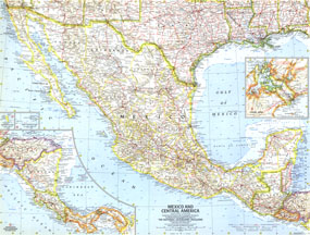
The Mexico and Central America map was published in October 1961, the same month Hurricane Hattie struck the coast of British Honduras (now Belize) and nearly destroyed Belize City. The capital was moved further inland to Belmopan in 1970. This map contains insets of Guadalupe Island and the Revilla Gigedo Islands as well as a map of the Panama Canal Zone. The 1961 Mexico and Central America map features:
• Inset map of the Panama Canal Zone
• Inset maps of Guadalupe Island and the Revilla Gigedo Islands
• Capitals, cities, and towns
• Pan American highway system, freeways, roads, railroads, canals, and places with scheduled air service
• Ocean bathymetry, mountains, passes, rivers, lakes, intermittent lakes, and dry salt lakes
• Oil fields and pipelines
• Ruins
Coverage Area: Mexico, Central America
|
|
 |
More Product Details
This map requires 7 business days to print and laminate prior to shipping.
Appearing in the October 1961 issue of the National Geographic Magazine, this Mexico And Central America map has been reproduced from its original cartography in order to bring to life a beautiful poster previously only seen in National Geographic Magazine. This reproduction holds true to the high standards that National Geographic Maps are known for.
Perfect for home, office or classroom, this map also makes a great gift. Map collectors will surely want to add this map to their library.
The Paper version is printed on high quaility semi-gloss paper, perfect for framing.
The Laminated version uses 3mm laminate on both sides for durability, is easy to clean and markable.
From the National Geographic Classic Maps collection, this reproduction is just one of hundreds of titles available here. These maps are Printed on Demand. Sizes are approximate and may vary due to the nature of the trimming and laminating processes.
|
|
Shipping Conditions
Maps.com ships to Dometic US only
 | This product can only be shipped to the Domestic U.S.A. (No APO's or PO Boxes) |  | This map requires 2 business days to print and laminate prior to shipping. |
|
|
|
|


 Click here to zoom!