SHOP BY YEAR :: FOR OFFICE :: FOR CLASSROOM :: GIFT IDEAS :: CUSTOMER SERVICE

Land Of The Maya Map 1989
Issue: October 1989
More Views
Enlarge Image
ZoomClick here to zoom!
Purchase Product :
Please select map format:
Laminated   
20" x 27" - $39.95
Laminated-w/Plastic Rails  (What are rails?)
20" x 27" - $51.95
Paper
20" x 27" - $29.95
Wallzilla Adhesive Format
20" x 27" - $59.95
Product Highlights
Land Of The Maya Map 1989
Item#: X NGC 101989a

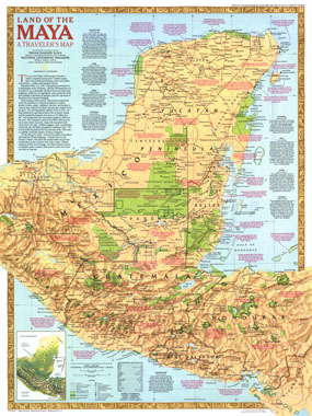
Half of a two-map set published in October 1989, this map accompanies the "Ancient Maya World" map. It features an abundance of historical notes about Mayan cities and their locations, and shows national parks and other preserved areas where one can explore the remains of this great civilization.

The 1989 Land of the Maya map features:
• An abundance of historical notes about Mayan culture and the pyramids, monuments and other architecture they left behind including information on nine Mayan cities
• Mayan language groups
• National parks, existing protected areas, and proposed protected areas
• Ruins, populated places of archaeological importance, points of interest, and museums
• Paved roads, unpaved roads, railroads, sacbe (Maya causeway), and airports
• Small physical map of the region
• Geographical equivalents

Coverage Area: Guatemala, southern Mexico, Honduras, El Salvador

More Product Details

This map requires 7 business days to print and laminate prior to shipping.

Appearing in the October 1989 issue of the National Geographic Magazine, this Land Of The Maya map has been reproduced from its original cartography in order to bring to life a beautiful poster previously only seen in National Geographic Magazine. This reproduction holds true to the high standards that National Geographic Maps are known for.

Perfect for home, office or classroom, this map also makes a great gift. Map collectors will surely want to add this map to their library.

The Paper version is printed on high quaility semi-gloss paper, perfect for framing.

The Laminated version uses 3mm laminate on both sides for durability, is easy to clean and markable.

From the National Geographic Classic Maps collection, this reproduction is just one of hundreds of titles available here. These maps are Printed on Demand. Sizes are approximate and may vary due to the nature of the trimming and laminating processes.
Shipping Conditions
Maps.com ships to Dometic US only

US FlagThis product can only be shipped to the Domestic U.S.A. (No APO's or PO Boxes)
TimeThis map requires 2 business days to print and laminate prior to shipping.