SHOP BY YEAR :: FOR OFFICE :: FOR CLASSROOM :: GIFT IDEAS :: CUSTOMER SERVICE

West Indies Map 1987 Side 2
Issue: November 1987
More Views
Enlarge Image
ZoomClick here to zoom!
Purchase Product :
Please select map format:
Laminated   
27" x 20.5" - $39.95
Laminated-w/Plastic Rails  (What are rails?)
27" x 20.5" - $51.95
Paper
27" x 20.5" - $29.95
Wallzilla Adhesive Format
27" x 20.5" - $59.95
Product Highlights
West Indies Map 1987 Side 2
Item#: X NGC 111987b

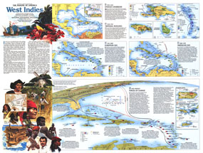
A region of contrasts, the islands of the West Indies are both tropical paradise and lands marred by a dark history of slavery, greed, and suffering. Part of the "Making of America" series, this work represents Side Two of a two-map set published in November 1987 and features an abundance of historical information about this culturally diverse region. Two articles, "Searching for Columbus's Lost Colony: La Navidad" and "Haiti - Against All Odds," accompanied the two maps.

The 1987 West Indies map Side 2 features:
• A historical introduction
• The Spanish Caribbean map (1492-1625) which contains information on explorers' routes, convoy routes, colonies, exports, and more
• The Imperial Rivalries map (1625-1763) showing European possession of the islands, peak migration periods of various peoples, trade routes, points of conflict, and more
• A map of the region from 1763-1823 containing information on migrations, chief exports, the end of slavery in the islands, and more
• A map detailing the United States' involvement in the region from 1898-1945 which includes oil refineries and pipelines, US leased military bases, US naval bases, exports, tourism areas, liquor producing areas, and more
• Maps showing activities in the region from 1945 to present including information on the economy, production and export, population, and more
• Colorful illustrations

Coverage Area: West Indies, Panama, Costa Rica, Nicaragua, northern Columbia, northern Venezuela

More Product Details

This map requires 7 business days to print and laminate prior to shipping.

Appearing in the November 1987 issue of the National Geographic Magazine, this West Indies map Side 2 has been reproduced from its original cartography in order to bring to life a beautiful poster previously only seen in National Geographic Magazine. This reproduction holds true to the high standards that National Geographic Maps are known for.

Perfect for home, office or classroom, this map also makes a great gift. Map collectors will surely want to add this map to their library.

The Paper version is printed on high quaility semi-gloss paper, perfect for framing.

The Laminated version uses 3mm laminate on both sides for durability, is easy to clean and markable.

From the National Geographic Classic Maps collection, this reproduction is just one of hundreds of titles available here. These maps are Printed on Demand. Sizes are approximate and may vary due to the nature of the trimming and laminating processes.
Shipping Conditions
Maps.com ships to Dometic US only

US FlagThis product can only be shipped to the Domestic U.S.A. (No APO's or PO Boxes)
TimeThis map requires 2 business days to print and laminate prior to shipping.