 |
|
|
|
|
Canada Map 1961
Issue: December 1961
|
|
|
|
|
|
|
| Product Highlights |
| Canada Map 1961 |
| Item#: X NGC 121961 |
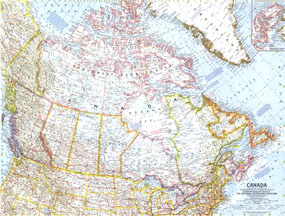
This map of the Great White North is a fine example of the detailed and vibrant cartography National Geographic is famous for. It appeared in the December 1961 issue with the article "Canada, My Country." Of particular note is the boundary marking the northern limit of wooded country. The 1961 Canada map features:
• Inset map of Ellesmere Island
• Thousands of place names including capitals, cities, and towns
• Freeways, roads, toll roads, railroads, places with scheduled air service, canals, and passes
• Geographical features including mountains, rivers, lakes, intermittent lakes, dry salt lakes, and glaciers
• Ocean bathymetry and information about icebergs and ice pack
• Northern limit of wooded country
• Oil pipelines
Coverage Area: Canada, northern United States
|
|
 |
More Product Details
This map requires 7 business days to print and laminate prior to shipping.
Appearing in the December 1961 issue of the National Geographic Magazine, this Canada map has been reproduced from its original cartography in order to bring to life a beautiful poster previously only seen in National Geographic Magazine. This reproduction holds true to the high standards that National Geographic Maps are known for.
Perfect for home, office or classroom, this map also makes a great gift. Map collectors will surely want to add this map to their library.
The Paper version is printed on high quaility semi-gloss paper, perfect for framing.
The Laminated version uses 3mm laminate on both sides for durability, is easy to clean and markable.
From the National Geographic Classic Maps collection, this reproduction is just one of hundreds of titles available here. These maps are Printed on Demand. Sizes are approximate and may vary due to the nature of the trimming and laminating processes.
|
|
Shipping Conditions
Maps.com ships to Dometic US only
 | This product can only be shipped to the Domestic U.S.A. (No APO's or PO Boxes) |  | This map requires 2 business days to print and laminate prior to shipping. |
|
|
|
|


 Click here to zoom!