 |
|
|
|
|
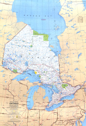
Ontario Canada Map 1978
Issue: December 1978
|
|
|
|
|
|
|
| Product Highlights |
| Ontario Canada Map 1978 |
| Item#: X NGC 121978a |
Half of a two-map set, the Ontario map is a wonderful travel map showing points of interest in its cities as well as the wilds of its national parks and campgrounds. Published in December 1978, its companion map features additional information on Canada's richest, most populous, and most urban province. The 1978 Ontario Canada map features:
• Notes highlighting particular points of interest
• Ski areas and points of interest
• Indian reserves, national parks, national wildlife reserves, and provincial and territorial parks and campgrounds
• Cities and towns
• Roads, passenger railroads, and airports
• Mountains, rivers, lakes, swamps, sand, and drainage divides
• Northern limit of wooded country
Coverage Area: Ontario
|
|
 |
More Product Details
This map requires 7 business days to print and laminate prior to shipping.
Appearing in the December 1978 issue of the National Geographic Magazine, this Ontario Canada map has been reproduced from its original cartography in order to bring to life a beautiful poster previously only seen in National Geographic Magazine. This reproduction holds true to the high standards that National Geographic Maps are known for.
Perfect for home, office or classroom, this map also makes a great gift. Map collectors will surely want to add this map to their library.
The Paper version is printed on high quaility semi-gloss paper, perfect for framing.
The Laminated version uses 3mm laminate on both sides for durability, is easy to clean and markable.
From the National Geographic Classic Maps collection, this reproduction is just one of hundreds of titles available here. These maps are Printed on Demand. Sizes are approximate and may vary due to the nature of the trimming and laminating processes.
|
|
Shipping Conditions
Maps.com ships to Dometic US only
 | This product can only be shipped to the Domestic U.S.A. (No APO's or PO Boxes) |  | This map requires 2 business days to print and laminate prior to shipping. |
|
|
|
|


 Click here to zoom!