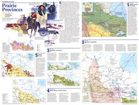
Published in December 1994 as half of a two-map set, this map of the Prairie Provinces is part of the "Making of Canada" series. With a collection of maps detailing periods of the province's exploration and settlement, this work provides a wonderful historical overview as well as an informative look at present-day Alberta, Saskatchewan, and Manitoba. The 1994 Prairie Provinces map Side 2 features:
• A section on Indians and the fur trade with a map showing the tribal groups, the arrival of the horse to the region, fur trade routes, explorers' routes, trading posts, missions, and more
• Information on European competition for the region from 1760-1870 including a map showing settlements, buffalo range and hunts, US Army forts, HBC posts, and more
• Maps and information about the settlement of the region featuring details on the various railroad lines
• A map and information on the region's wheat industry including grain elevators, agribusiness centers, railroads, and more
• A present-day map showing natural resources, industry, agriculture, hydroelectric sites, and more
• A map and information on immigration patterns
• Historical illustrations
Coverage Area: Alberta, Saskatchewa, Manitoba
|


 Click here to zoom!
