SHOP BY YEAR :: FOR OFFICE :: FOR CLASSROOM :: GIFT IDEAS :: CUSTOMER SERVICE

Atlantic Ocean Map 1968
Issue: June 1968
More Views
Enlarge Image
ZoomClick here to zoom!
Purchase Product :
Please select map format:
Laminated   
19" x 25" - $19.95
Laminated-w/Plastic Rails  (What are rails?)
19" x 25" - $29.95
Paper
19" x 25" - $14.95
Wallzilla Adhesive Format
19" x 25" - $34.95
Product Highlights
Atlantic Ocean Map 1968
Item#: X NGC 061968a

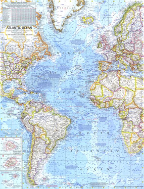
Colorful and full of historical and geographical information, this map was published in June 1968. Complete with ocean bathymetry, notes on ocean currents, winds and physical features of the Atlantic as well as land features, it appeared in the same issue of National Geographic was a map of the Atlantic Ocean floor. Both Atlantic maps are wonderful companions to the two similar maps of the Pacific published in 1969 and the Arctic maps of 1971.

The 1968 Atlantic Ocean map features:
• Inset maps of Ascension Island, St. Helena, and the Tristan da Cunha Group
• Ocean bathymetry, cold currents, warm currents, prevailing winds, and areas of gulfweed
• An abundance of historical and geographic notes
• Thousands of place names including capitals, cities, and towns
• Geographical features including mountainous regions, major rivers, major lakes, deserts, glaciers, and more
• Principal airports and canals
• Distances across the Atlantic

Coverage Area: South America, eastern North America, Europe, western Africa

More Product Details

This map requires 7 business days to print and laminate prior to shipping.

Appearing in the June 1968 issue of the National Geographic Magazine, this Atlantic Ocean map has been reproduced from its original cartography in order to bring to life a beautiful poster previously only seen in National Geographic Magazine. This reproduction holds true to the high standards that National Geographic Maps are known for.

Perfect for home, office or classroom, this map also makes a great gift. Map collectors will surely want to add this map to their library.

The Paper version is printed on high quaility semi-gloss paper, perfect for framing.

The Laminated version uses 3mm laminate on both sides for durability, is easy to clean and markable.

From the National Geographic Classic Maps collection, this reproduction is just one of hundreds of titles available here. These maps are Printed on Demand. Sizes are approximate and may vary due to the nature of the trimming and laminating processes.
Shipping Conditions
Maps.com ships to Dometic US only

US FlagThis product can only be shipped to the Domestic U.S.A. (No APO's or PO Boxes)
TimeThis map requires 2 business days to print and laminate prior to shipping.