SHOP BY YEAR :: FOR OFFICE :: FOR CLASSROOM :: GIFT IDEAS :: CUSTOMER SERVICE

Pacific Ocean Map
Issue: June 1992
More Views
Enlarge Image
ZoomClick here to zoom!
Purchase Product :
Please select map format:
Laminated   
31" x 20" - $39.95
Laminated-w/Plastic Rails  (What are rails?)
31" x 20" - $51.95
Paper
31" x 20" - $29.95
Wallzilla Adhesive Format
31" x 20" - $59.95
Product Highlights
Pacific Ocean Map
Item#: X NGC 061992a

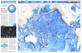
This attractive physical map of the Pacific Ocean floor appeared in the June 1992 issue of National Geographic. It contains an article entitled "Deep-Sea Vents: Worlds Without Sun" and additional information on the life forms that thrive in the deepest waters of the Pacific. The map's detail of such submarine terrain as fracture zones, troughs, trenches, and the countless seamounts is stunning. A wonderful companion to the ocean floor map of the Indian Ocean which appeared in the same issue.

The 1992 Pacific Ocean map features:
• Ocean floor illustrated in stunning relief
• Ocean depths noted
• Names of submarine terrain as well as major geographic regions
• An article entitled "Deep-Sea Vents: Worlds Without Sun"
• Illustrations and information about the creatures who live in the deepest parts of the ocean
• An inset map showing the Pacific Ocean plates
• An inset map showing the active spreading areas in the ocean and selected vent sites

Coverage Area: Pacific Ocean, Bering Sea, Gulf of Mexico, Philippine Sea, South China Sea, Sea of Okhotsk, Coral Sea, Tasman Sea

More Product Details

This map requires 7 business days to print and laminate prior to shipping.

Appearing in the June 1992 issue of the National Geographic Magazine, this Pacific Ocean map has been reproduced from its original cartography in order to bring to life a beautiful poster previously only seen in National Geographic Magazine. This reproduction holds true to the high standards that National Geographic Maps are known for.

Perfect for home, office or classroom, this map also makes a great gift. Map collectors will surely want to add this map to their library.

The Paper version is printed on high quaility semi-gloss paper, perfect for framing.

The Laminated version uses 3mm laminate on both sides for durability, is easy to clean and markable.

From the National Geographic Classic Maps collection, this reproduction is just one of hundreds of titles available here. These maps are Printed on Demand. Sizes are approximate and may vary due to the nature of the trimming and laminating processes.
Shipping Conditions
Maps.com ships to Dometic US only

US FlagThis product can only be shipped to the Domestic U.S.A. (No APO's or PO Boxes)
TimeThis map requires 2 business days to print and laminate prior to shipping.