SHOP BY YEAR :: FOR OFFICE :: FOR CLASSROOM :: GIFT IDEAS :: CUSTOMER SERVICE

Pacific Ocean, And The Bay Of Bengal Map 1943
Issue: September 1943
More Views
Enlarge Image
ZoomClick here to zoom!
Purchase Product :
Please select map format:
Laminated   
37" x 27.5" - $59.95
Laminated-w/Plastic Rails  (What are rails?)
37" x 27.5" - $76.95
Paper
37" x 27.5" - $49.95
Wallzilla Adhesive Format
37" x 27.5" - $89.95
Product Highlights
Pacific Ocean, And The Bay Of Bengal Map 1943
Item#: X NGC 091943

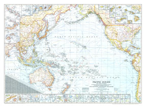
Published in September 1943 during World War II, this map of the Pacific Ocean and the Bay of Bengal contains an abundance of detail. With inset maps of over fifty islands, boundaries and notes showing the political administration of islands, typical storm tracks, time zones, and both airline and nautical distances, this work makes a fine addition to any map collection.

The 1943 Pacific Ocean and the Bay of Bengal map features:
• Inset maps of over fifty islands
• Airline distances in statute miles
• Time zone boundaries and clocks showing the time when it is midnight at Greenwich
• Distances in nautical miles, typical storm tracks, and depth curves in meters
• Capitals and cities
• Principal railways and roads
• Mountain relief, reefs, and glaciers

Coverage Area: Pacific Ocean, Bay of Bengal, United States, western Canada, Central America, West Indies, eastern Asia, Indonesia, Australia, New Zealand, Pacific coastline of South America, Oceania, Bering Sea, South China Sea, Sea of Japan, East China Sea, Tasman Sea

More Product Details

This map requires 7 business days to print and laminate prior to shipping.

Appearing in the September 1943 issue of the National Geographic Magazine, this Pacific Ocean, And The Bay Of Bengal map has been reproduced from its original cartography in order to bring to life a beautiful poster previously only seen in National Geographic Magazine. This reproduction holds true to the high standards that National Geographic Maps are known for.

Perfect for home, office or classroom, this map also makes a great gift. Map collectors will surely want to add this map to their library.

The Paper version is printed on high quaility semi-gloss paper, perfect for framing.

The Laminated version uses 3mm laminate on both sides for durability, is easy to clean and markable.

From the National Geographic Classic Maps collection, this reproduction is just one of hundreds of titles available here. These maps are Printed on Demand. Sizes are approximate and may vary due to the nature of the trimming and laminating processes.
Shipping Conditions
Maps.com ships to Dometic US only

US FlagThis product can only be shipped to the Domestic U.S.A. (No APO's or PO Boxes)
TimeThis map requires 2 business days to print and laminate prior to shipping.