SHOP BY YEAR :: FOR OFFICE :: FOR CLASSROOM :: GIFT IDEAS :: CUSTOMER SERVICE

Southern South America Map 1958
Issue: March 1958
More Views
Enlarge Image
ZoomClick here to zoom!
Purchase Product :
Please select map format:
Laminated   
19" x 25" - $19.95
Laminated-w/Plastic Rails  (What are rails?)
19" x 25" - $29.95
Paper
19" x 25" - $14.95
Wallzilla Adhesive Format
19" x 25" - $34.95
Product Highlights
Southern South America Map 1958
Item#: X NGC 031958

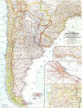
The Southern South America map was published in March 1958 with the article "Argentina: Young Giant of the Far South." This map features insets of the three most prominent capitals in the region: Buenos Aires, Santiago, and Montevideo. A fine companion to the Eastern South America map of 1955.

The 1958 Southern South America map features:
• Inset maps of Buenos Aires, Montevideo, and Santiago
• Capitals, cities, and towns
• Mountain relief, rivers, and lakes
• Pan American Highway system, railways, roads, and places with scheduled air service
• Oil fields and pipelines
• Depth curves and soundings in fathoms, elevations in feet

Coverage Area: Argentina, Chile, Uraguay, Paraguay, Falkland Islands, southern Brazil, southern Bolivia

More Product Details

This map requires 7 business days to print and laminate prior to shipping.

Appearing in the March 1958 issue of the National Geographic Magazine, this Southern South America map has been reproduced from its original cartography in order to bring to life a beautiful poster previously only seen in National Geographic Magazine. This reproduction holds true to the high standards that National Geographic Maps are known for.

Perfect for home, office or classroom, this map also makes a great gift. Map collectors will surely want to add this map to their library.

The Paper version is printed on high quaility semi-gloss paper, perfect for framing.

The Laminated version uses 3mm laminate on both sides for durability, is easy to clean and markable.

From the National Geographic Classic Maps collection, this reproduction is just one of hundreds of titles available here. These maps are Printed on Demand. Sizes are approximate and may vary due to the nature of the trimming and laminating processes.
Shipping Conditions
Maps.com ships to Dometic US only

US FlagThis product can only be shipped to the Domestic U.S.A. (No APO's or PO Boxes)
TimeThis map requires 2 business days to print and laminate prior to shipping.