 |
|
|
|
|
Archaeology Of South America Map 1982
Issue: March 1982
|
|
|
|
|
|
|
| Product Highlights |
| Archaeology Of South America Map 1982 |
| Item#: X NGC 031982a |
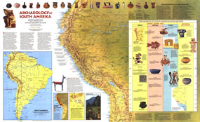
Explore the fascinating world of the Inca and other South American civilizations with this informative "Archaeology of South America" map. Published in March 1982 with the "Indians of South America" map, this work is filled with illustrations and information about pre-Columbian artifacts and archeological sites including Cuzco and Machu Picchu. The 1982 Archaeology of South America map features:
• A map showing pre-Columbian cultures, ruins, and sites
• An abundance of historical notes
• Country capitals and selected cities
• Mountain relief, rivers, and lakes
• "The Progression of Cultures in Pottery" showing illustrations and information about artifacts including the clues that the pieces give archeaologists about early South American cultures
• "The Growth of South American Civilization" time line featuring artifacts and sites
• Three inset maps focused on the Incas including the growth of the Inca Empire, Cuzco, and Machu Picchu
Coverage Area: South America
|
|
 |
More Product Details
This map requires 7 business days to print and laminate prior to shipping.
Appearing in the March 1982 issue of the National Geographic Magazine, this Archaeology Of South America map has been reproduced from its original cartography in order to bring to life a beautiful poster previously only seen in National Geographic Magazine. This reproduction holds true to the high standards that National Geographic Maps are known for.
Perfect for home, office or classroom, this map also makes a great gift. Map collectors will surely want to add this map to their library.
The Paper version is printed on high quaility semi-gloss paper, perfect for framing.
The Laminated version uses 3mm laminate on both sides for durability, is easy to clean and markable.
From the National Geographic Classic Maps collection, this reproduction is just one of hundreds of titles available here. These maps are Printed on Demand. Sizes are approximate and may vary due to the nature of the trimming and laminating processes.
|
|
Shipping Conditions
Maps.com ships to Dometic US only
 | This product can only be shipped to the Domestic U.S.A. (No APO's or PO Boxes) |  | This map requires 2 business days to print and laminate prior to shipping. |
|
|
|
|


 Click here to zoom!