 |
|
|
|
|
South America Map 1942
Issue: October 1942
|
|
|
|
|
|
|
| Product Highlights |
| South America Map 1942 |
| Item#: X NGC 101942 |
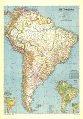
This map of South America, published in October 1942, shows a continent still harboring unexplored rivers and revealing vast roadless areas of wilderness. The article "Air Cruising Through New Brazil" accompanied this map which featured information on the climate and natural resources of the region. The 1942 South America map features:
• An Airways and Relief inset
• Mean annual precipitation and temperature
• Chief natural resources
• Inset map of the Galapagos Islands
• Geographical features including mountains, rivers, lakes, deserts, glaciers, salt pans, and swamps
• Principal ship routes, limits of navigation, roads, railways, and the Pan American Highway including sections proposed or under construction
• Thousands of place names including capitals, cities, and towns
Coverage Area: South America
|
|
 |
More Product Details
This map requires 7 business days to print and laminate prior to shipping.
Appearing in the October 1942 issue of the National Geographic Magazine, this South America map has been reproduced from its original cartography in order to bring to life a beautiful poster previously only seen in National Geographic Magazine. This reproduction holds true to the high standards that National Geographic Maps are known for.
Perfect for home, office or classroom, this map also makes a great gift. Map collectors will surely want to add this map to their library.
The Paper version is printed on high quaility semi-gloss paper, perfect for framing.
The Laminated version uses 3mm laminate on both sides for durability, is easy to clean and markable.
From the National Geographic Classic Maps collection, this reproduction is just one of hundreds of titles available here. These maps are Printed on Demand. Sizes are approximate and may vary due to the nature of the trimming and laminating processes.
|
|
Shipping Conditions
Maps.com ships to Dometic US only
 | This product can only be shipped to the Domestic U.S.A. (No APO's or PO Boxes) |  | This map requires 2 business days to print and laminate prior to shipping. |
|
|
|
|


 Click here to zoom!